
1. Guidelines:
a. Try to find an alternate within 50-250 miles for FW and 20-50 miles for RW.
(1) Too close, and you’d have the same weather as your primary destination so it’s of almost no use
(2) Too far, and you won’t have the gas to be legal or safe
b. Ensure it has DoD approaches (IAPs). If you can’t find one with DoD, request a Conformance Review.
c. Try to find an alternate in the same country, in a country we already have clearances for or a blanket clearance country. Consider Airports of Entry and customs (see FCG).
d. EDDS, ETOU, EDDN, ETAR, ETHN – All are close to each other. Use them as alternates for each other.
e. ALWAYS put your alternate in OPARS on the “Divert” tab, put the JEPPs for your alternates in the folder (UKKB alt.pdf) and include in your NOTAMs.
1. Methods:
a. NGA – Click here and see below for instructions (this is the best way!).
b. iPad – Open Foreflight. Click on Maps at the bottom. Search for your airport. Long press near it and see if it has DoD approaches
You’ll know because when you look it up, it will have “Approaches (2)” as you scroll down.
NGA INSTRUCTIONS
1. On the first dropdown menu “Airfield Option”, select the first dropdown “Airfields w/DoD Procedures Only” like below.
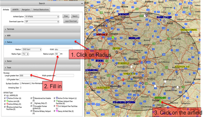
3. Now click the grey “Radius” bar
4. Fill in “ICAO”, “Radius Length” (200), Do NOT fill in Runway length or any other items below.
5. DO NOT HIT ENTER!.
6. Go to the top and click “Search”
7. The map will draw a circle with all of the DoD approaches. Find one with the right distance to your destination.
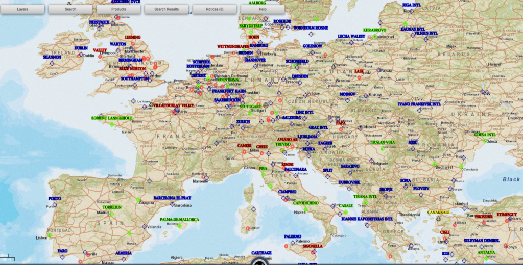
Click here to see all airports with DoD procedures in Europe.
Now, let’s assume that the weather forecast at the destination is for low IFR conditions and an alternate airport is required. There are legal requirements that the filed alternate airport needs to meet, but similar to the weather briefing, start with a big-picture view of what’s causing the IFR conditions at the destination and a few practical aspects about potential alternate airports:
Is there a cold front moving through at the arrival time forecast to cause localized areas of low visibility? Look for a nearby airport to the east of the destination ahead of the front.
Is there widespread fog? You’ll need to search further away from the weather system over the destination and carry plenty of extra fuel.

Is there another cloud layer above the fog and no wind? The fog may not clear out as fast as forecast due to inadequate solar heating.
What time of day is the flight? Low visibility conditions tend to improve several hours after sunrise into late morning, but then deteriorate at night as temperatures cool.
Is there rising terrain nearby or large variations in airport elevations within 50 NM of the destination? A nearby airport at a lower altitude may provide additional clearance under a cloud layer (with the caveat that it could be prone to fog if near a body of water).
What services are available at the alternate airport? As we’ll discuss later in this article, the alternate airport needs to have reliable weather reporting, and you’ll likely need fuel and/or FBO services when you get there. Think about choosing a towered airport with an ATIS broadcast and a 24-hour FBO.
If you are planning with ForeFlight or Garmin Pilot, you’ll find some helpful Alternate Airport planning tools to help you decide. In ForeFlight, enter your basic flight plan information, and then tap the Alternate field. This will display a list of suggested alternate airports and key information: airport name, forecast weather for the arrival time, longest runway length and the time/fuel to divert there after executing a missed approach at the planned destination.


This symbol indicates that nonstandard alternate minimums apply and you need to refer to the IFR Alternate Airport Minimums reference. If you are using paper charts, these can be found in the front of the approach chart book. If you are a ForeFlight user, navigate to the Airports screen, select the Procedures tab, select Arrival and then Alternate Minimums.
